~Christopher McCandless~
Week Four saw things transition......with the start of a new job. One of my friends was having a baby! The Canal Walk Maintenance Team was down a man with the wonderful arrival, and I happened to have a lifestyle that fit into the job, plus I knew I could learn a lot and was a very hard worker. The Canal Walk area is overseen and operated by Venture Richmond, a non-profit organization with the following mission:
Venture Richmond engages business and community leaders in partnering with the city to enhance the vitality of the community, particularly downtown, through economic development, marketing, promotion, advocacy and events.
Focus
- Support the strategic direction of the city
- Engage senior business and community leaders
- Provide a resource to the city to advance key economic and promotional initiatives
- Leverage resources of organizations throughout the region
- Provide enhanced services downtown
- Marketing, promotion and events management
- The Clean & Safe program, including sidewalk cleaning and safety ambassadors
- Landscaping, riverfront canal management, beautification
- Canal operations, tour boats, etc.
- Canal Walk planning and development
- Support efforts to enhance the business climate
- Support teacher recruitment and recognition initiative
- Help build successful school-business partnerships
- Ensure diverse representation and benefit
- Maintain board makeup that reflects diversity of community
- Promote corporate supplier diversity
- Operate in an accountable and efficient manner
- Increase return on investment to private investors and city government
This is an incredible organization and I was excited about the opportunity. Seriously, the things Venture Richmond create all have one goal in mind.......MAKE RVA BETTER! To be able to participate in that style of a mission meant a lot to me, because I felt that my mission paralleled in a way, the people who work there are good people, and it is a quality organization. I report to work at The Canal Walk Marina where the Canal Walk tour boats are housed and maintained. This work location gives me the option to literally paddle to work. I can walk to the Western Tip of the island, cross the pool above the Middle Lines and run Pipeline before paddling to The Fourteenth Street takeout and then walking down the path to the marina. I even have the option of stopping at Third Drop and walking up the Canal Walk to get my morning coffee. Then I get back in my boat and paddle the rest of the way to work. Pretty cool, isn't it?
So if you think about it, I am not that different from all of you. I get up, eat breakfast, dig a cat hole (yep....it is what you think it is....like I said, shit happens), take a morning walk, brush my teeth, and start my morning commute. Sometimes I even shower. (otherwise known as a bucket with holes poked in the bottom. Fill it with river water, hang it in a tree, and BAM!, you have a shower. Chris McCandless taught me that in his writing.) The only difference between me and all of you is while you sit in traffic, I paddle whitewater. Once I get to work, I change into my work clothes and start my day. I get off work around 3:30pm and walk to the coffee shop by way of the Canal Walk and spend an hour or so writing and checking messages. On the way there, I stop and talk to the homeless who are lining the Floodwall ledges and the Canal Walk, and sometimes I walk to the coffee shop with one of them. (I will discuss this in detail in a later post) Then I walk back down to The Canal, where I can make the choice to walk to my car, or drive my car (if it is at work) back across the bridge, where I park, walk up the Floodwall, and commute back home to the island by way of kayak. This is a normal day for me. It is a good life, minus one BIG thing, but you all know what that is by now.
The other benefit to my job is that it immerses me in the rich history of our city and the river. If you have ever taken a Canal Boat Tour then you know you are treated to a forty minute history tour of the Bottom and The Canal, and you can learn a lot. The tours are cheap, only six bucks, so it is a great thing for Richmond, and if you haven't been, you should go. Although I am not a boat operator, I pay close attention to everything that I see and am learning, and my boss and closest friend loves his job and is very good at what he does; so when you see the Canal Walk and think how nice it looks, that is the result of Venture Richmond and dedication of my boss.......so to the organization, Thank You for the opportunity and for believing in me.
"A rich man's war and a poor man's fight..."
~Southern opposition slogan, in The Civil War by Shelby Foote~
Our city's history is rich and tragic at the same time. As most of you know, on April 2nd, Eighteen Sixty Five (broken key) the Confederate troops burned Richmond to the ground as they crossed the Manchester Bridge to retreat South and escape the advancing Union Army. What you may not know, is the intention was not to burn the entire city, just the buildings that would benefit the Union Army. However, the night of the siege, a strong wind was blowing and the fire spread throughout Richmond, causing astronomical damage that impacts our city to this day. The following images show the devastation endured immediately after the Civil War.


- This fire destroyed over 1000 buildings in the Richmond area. Before the Civil War, the Port of Richmond helped the city to grow dramatically, and Richmond was considered to be one of the largest and most vibrant cities on the East Coast. After the Civil War, the area was devastated and although reconstruction helped, we were never the same. The ports of Savannah and Baltimore were then built, locking us between ports and driving shipping either north or south.
- There are many lesser known stories during this time as well. The following is an exert from the Canal Walk Tour:
"Lincoln's visit to Richmond (at the conclusion of the War) came just two days after Jefferson Davis and his Confederate Cabinet fled by special trains to Danville, Virginia. Lincoln's character was on display as he stopped in Richmond. After arriving at Rockett's Landing on April Fourth, Lincoln was rowed by 12 sailors to a wharf near Libby Prison around 17th Street (remember that during this time in Richmond, the Canal Locks came much deeper into the city center, all the way to the James Center). He stepped out and found no reception committee, only a Northern reporter he recognized, Charles S. Coffin of the Boston Journal. Coffin described a scene in which a party of 20 -- Lincoln and his 12 year old son Tad, 12 sailors with carbines, four naval officers, Coffin and a black guide -- walked toward the house that Jefferson Davis had vacated recently. As they stepped through the streets, Lincoln 'manifested no signs of exultation', his face a mask of 'indescribable sadness' as a great column of smoke rose above the destroyed city, Coffin wrote. Crowds of freed slaves, meanwhile, swelled around him, praising God and blessing Lincoln........Lincoln walked in silence. 'It was the man of the people among the people,' Coffin wrote. Five days later, on April 9th, the day Lee surrendered, Lincoln was back in Washington. Five days after that, on April (Fourteenth) he was mortally wounded at Ford's Theatre. He died the next day."
 |
| This is a picture of the original Turning Basin that was located where the James Center is today. The State Capital is on the hillside. Lincoln was rowed near Libby Prison, close to where the parking lot of Main Street Station is today. |
The next time you take a walk to the Canal, or the river, think about the footsteps of those who walked there before you, and consider yourself blessed to have never have had to witness what our city had to endure to get to where it is today.
“The river itself portrays humanity precisely, with its tortuous windings, its accumulation of driftwood, its unsuspected depths, and its crystalline shallows, singing in the Summer sun. Barriers may be built across its path, but they bring only power, as the conquering of an obstacle is always sure to do. Sometimes when the rocks and stone-clad hills loom large ahead, and eternity itself would be needed to carve a passage, there is an easy way around. The discovery of it makes the river sing with gladness and turns the murmurous deeps to living water, bright with ripples and foam.”
~Myrtle Reed~
Not only is the deeply enriched history of our city an amazing topic, but the history of our river and it's great floods are an intriguing topic to research as well. DJ Jennings, who is one of the most knowledgeable historians of the James I know, created the following statistics to help me understand the behavior of the James, as well as the chances of seeing a major flood during my time on the island.
James River Historic Flood Data For Richmond


My theory is that the reading of forty five feet was a different gauge system, not accurate because it was in 1771, and if it was the Locks Gauge then the tidal swell was fully in. Regardless, a reading of forty five feet shows the power the James is capable of producing at Flood. The following images are from different floods throughout the recent history of the city.
These images were all taken before the construction of the Floodwall, and since it was built in the early 90's there has only been one flood greater than 20 feet, and it barely reached the Floodwall. When the flood does finally come that will require the wall (and it will come one day), the constriction of the water through the Floodwall will probably make the flood that much worse in the actually river, which is where I plan to be. Plus, the island is located right in the center of the Floodwall, so it is in a pretty intense spot for a flood, as the following picture illustrates.

The trees in the middle of the picture are what was left of the island I live on during the Camille flood of '69, but the river is also completely washed out (meaning the rapids are gone). The train bridge below the island has giant strainers (piles of trees) against the upstream side of it, which would create a deadly situation. These photos do help me understand the behavior of the river at flood. Take all the water that you see in the above picture spilling into the Manchester District (Southside), and push it back into the river and then dam it up with a giant wall. That is what the flood would be like today, which if you think about it, is bothersome to anyone who would happen to be on the island at the time of a major flood.
My interest in the history of The James, The Canal, our city, and The Civil War comes from a childhood filled with history lessons from my father. It is one of the things that he passed down to me, and hopefully will be something I am able to pass down to my sons one day. Until I am allowed that chance again, I hope that you enjoy reading about our great city and river, because both are truly unique attributes we should never take for granted. .

You can clearly see from the statistics that
our city is overdue for a twenty plus foot flood. The other statistic that I found interesting
was the months of the year that these floods are most likely to occur. The only two months out of the year that were
not on this chart were May and July. I
found this surprising because it shows that The James is capable of flooding at
any time of the year, and its flood patterns are unpredictable. In fact, the data for monthly 20+ foot floods is evenly dispersed throughout the year.
20+ Foot Floods by Month
January 1
February 1
March 2
April 2
May 0
June 1
July 0
August 2
September 3
October 1
November 1
December 2
This data shows that floods through the James River section of Richmond can happen from a variety of weather patterns. Winter time brings floods caused from winter rains and snows in the mountains that cover the entire watershed with evenly dispersed rains. Additionally, during this time of the year the leaves are not on the trees, increasing the water table and allowing for more run-off. In the spring, heavy thundershowers and spring rains in the mountains can create large rises, especially when the patterns persist for days and even weeks at a time. And in the late summer and early fall, tropical systems moving west from the Atlantic Ocean slip up the east coast and create large rainfall totals in the mountains, causing quick rises in the James, which can allow the river to transition from low water summer flows to major floods overnight.
One consideration to take into account concerning floods is that the data collected above only dates back to 1871. However, the following historical plaque is located in Henrico County.

My theory is that the reading of forty five feet was a different gauge system, not accurate because it was in 1771, and if it was the Locks Gauge then the tidal swell was fully in. Regardless, a reading of forty five feet shows the power the James is capable of producing at Flood. The following images are from different floods throughout the recent history of the city.
 |
| Looking out at the south side of Belle Isle. Camille in 1969 |
 |
| South side of Belle Isle in eighty five flood |
 |
| Fourteenth Street Bridge and Southern States Silos in 1972 Agnes Flood |
.jpg) |
| The old Manchester Bridge with the water to the top of the Stone Pillars |
 |
| Shockhoe Bottom in 1972 |
These images were all taken before the construction of the Floodwall, and since it was built in the early 90's there has only been one flood greater than 20 feet, and it barely reached the Floodwall. When the flood does finally come that will require the wall (and it will come one day), the constriction of the water through the Floodwall will probably make the flood that much worse in the actually river, which is where I plan to be. Plus, the island is located right in the center of the Floodwall, so it is in a pretty intense spot for a flood, as the following picture illustrates.
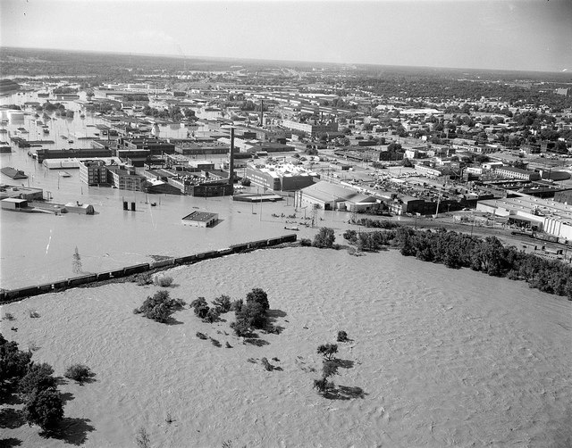
The trees in the middle of the picture are what was left of the island I live on during the Camille flood of '69, but the river is also completely washed out (meaning the rapids are gone). The train bridge below the island has giant strainers (piles of trees) against the upstream side of it, which would create a deadly situation. These photos do help me understand the behavior of the river at flood. Take all the water that you see in the above picture spilling into the Manchester District (Southside), and push it back into the river and then dam it up with a giant wall. That is what the flood would be like today, which if you think about it, is bothersome to anyone who would happen to be on the island at the time of a major flood.
My interest in the history of The James, The Canal, our city, and The Civil War comes from a childhood filled with history lessons from my father. It is one of the things that he passed down to me, and hopefully will be something I am able to pass down to my sons one day. Until I am allowed that chance again, I hope that you enjoy reading about our great city and river, because both are truly unique attributes we should never take for granted. .